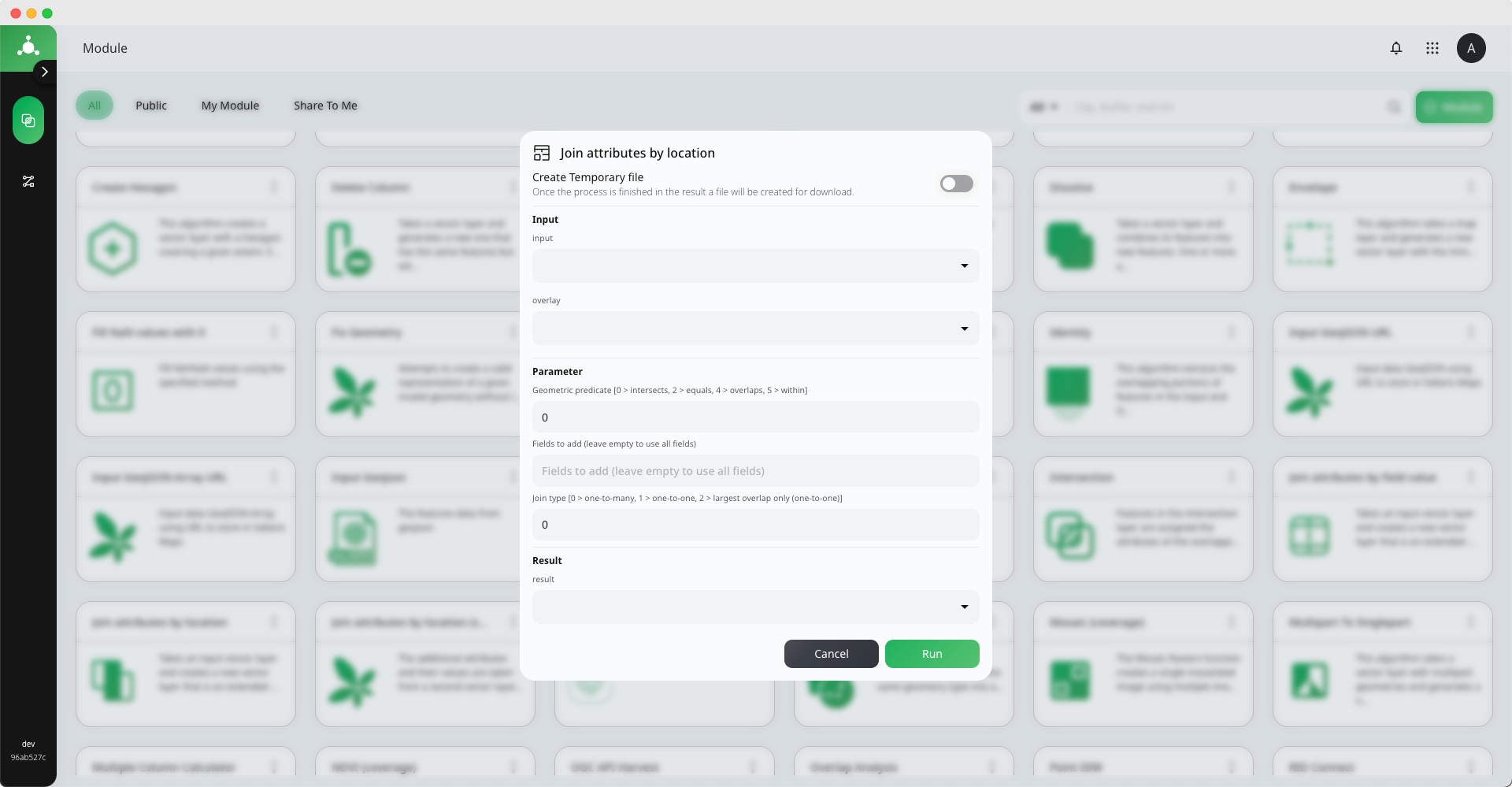
Join attributes by location
ProcessId : 2142ccad46a21053de2f8fa9
Join attributes by location เป็นเครื่องมือสำหรับเชื่อมข้อมูลตารางของข้อมูลที่มีการ Intersec กันและมีการใช้ข้อมูล 2 ส่วน คือข้อมูล Input และข้อมูล Overlay ผลลัพธ์จะได้ข้อมูลคุณสมบัติ (Features) ของข้อมูล Input ข้อมูลในตารางจะเพิ่มข้อมูลของ Overlay เข้ามาด้วย
วิธีการใช้งาน
Input
- Input : ระบุข้อมูลที่ต้องการนำมาเชื่อมข้อมูลตาราง โดยจะเป็นข้อมูลประเภท Vector (Point, Line, Polygon) ซึ่งสามารถนำ Features Collection ที่เคยนำเข้ามาแล้วมาสร้างและสามารถนำข้อมูล GeoJSON มาใช้ในการสร้างได้
- Overlay ระบุข้อมูลที่ต้องการนำมาเชื่อมข้อมูลตารางที่นำมา Join กับข้อมูลในส่วนของ Input โดยข้อมูลในส่วน Ovelay ต้องเป็นข้อมูลที่อยู่ในรูปแบบ Polygon เท่านั้น
Parameter
-
Geometric predicate เลือกรูปแบบของการของการซ้อนทับกับของข้อมูล
 0 = intersects          3 = touches
 1 = contains            4 = overlaps
2 = equals 5 = within -
Fields to add กำหนด field ที่ต้องการเชื่อมข้อมูลตารางได้ หากไม่ระบุจะใช้ทุก Field ในการเชื่อมต่อ
-
Join type เลือกรูปแบบของการเชื่อมตารางได้
0 = one-to-many           2 = largest overlap only (one-to-one),
1 = one-to-one            3 = largest overlap only (one-to-one)
Result ทำการเลือกประเภทของผลลัพธ์ซึ่งมีอยู่ 2 ประเภท คือ Vallaris Feature GeoJSON
- Vallaris Feature จะต้องทำการสร้าง Features Collection ไว้สำหรับเก็บข้อมูลผลลัพธ์
- GeoJSON จะได้ผลลัพธ์ออกมาเป็น GeoJSON
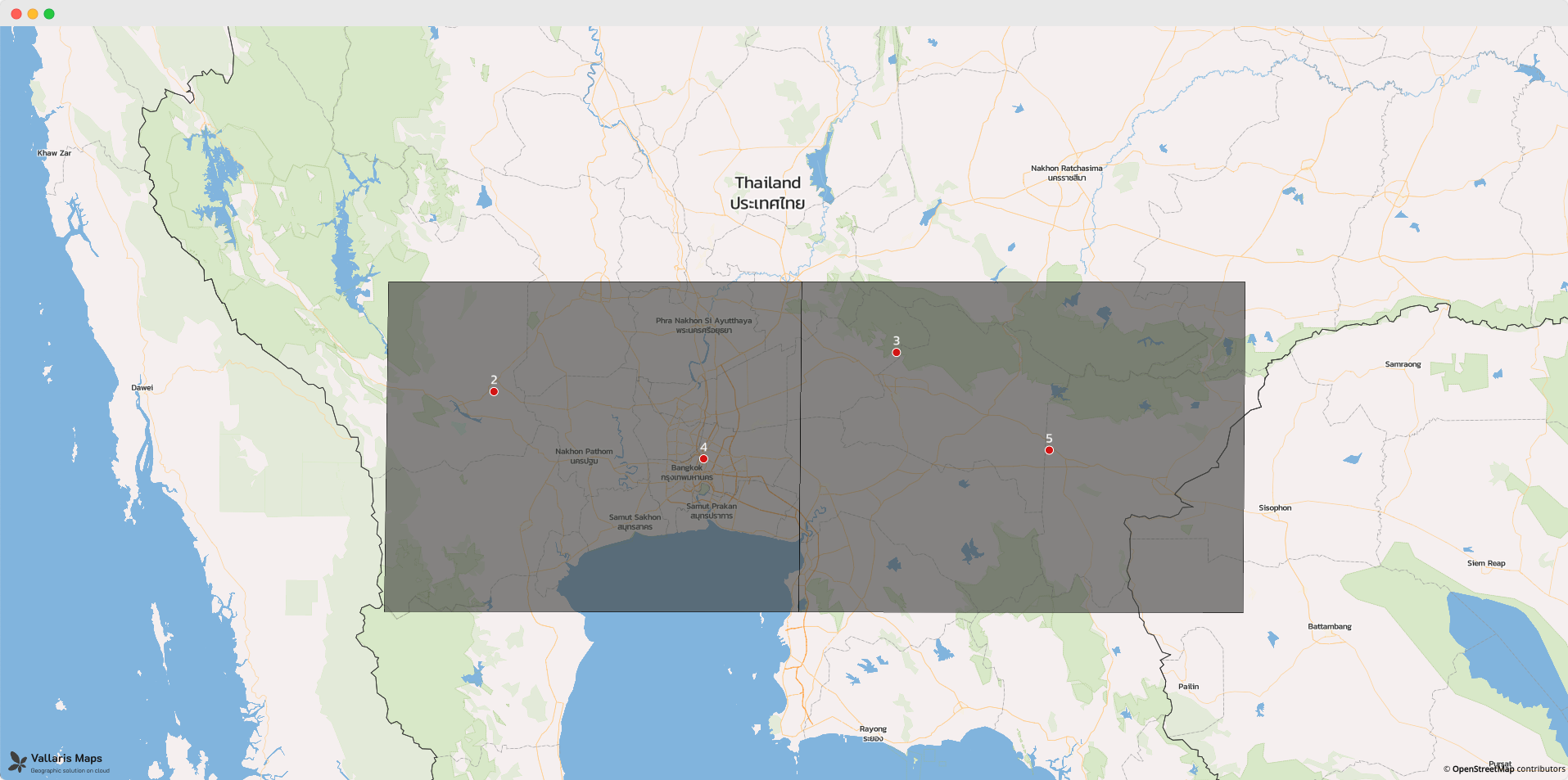
ภาพตัวอย่างข้อมูล Input เป็นข้อมูลประเภทจุดและข้อมูล Overlay เป็นข้อมูลประเภท Polygon
จะเห็นได้ว่าตัวอย่างผลลัพธ์ที่ฟิลด์ "data_2" ของในแต่จุดอ้างอิงตามตำแหน่งของจุดที่อยู่ใน Polygon
ตัวอย่างข้อมูล GeoJSON : Input
{
  "type": "FeatureCollection",
  "name": "point",
  "features": [
    {
      "type": "Feature",
      "properties": {
        "data": 2
      },
      "geometry": {
        "type": "Point",
        "coordinates": [
          99.68027451261905,
          14.0803602942941
        ]
      }
    },
    {
      "type": "Feature",
      "properties": {
        "data": 4
      },
      "geometry": {
        "type": "Point",
        "coordinates": [
          100.56322044876401,
          13.805271610671046
        ]
      }
    },
    {
      "type": "Feature",
      "properties": {
        "data": 5
      },
      "geometry": {
        "type": "Point",
        "coordinates": [
          102.01852832341501,
          13.840766924686925
        ]
      }
    },
    {
      "type": "Feature",
      "properties": {
        "data": 3
      },
      "geometry": {
        "type": "Point",
        "coordinates": [
          101.37517575687723,
          14.240089207365552
        ]
      }
    }
  ]
}
ตัวอย่างข้อมูล GeoJSON : Overlay
{
  "type": "FeatureCollection",
  "name": "example_polygon",
  "features": [
    {
      "type": "Feature",
      "properties": {
        "data": 20
      },
      "geometry": {
        "type": "MultiPolygon",
        "coordinates": [
          [
            [
              [
                100.97645526256841,
                14.52848863374456
              ],
              [
                100.96403261172851,
                13.177525354906454
              ],
              [
                99.21883543041264,
                13.179666701141198
              ],
              [
                99.23658308742057,
                14.52848863374456
              ],
              [
                100.97645526256841,
                14.52848863374456
              ]
            ]
          ]
        ]
      }
    },
    {
      "type": "Feature",
      "properties": {
        "data": 10
      },
      "geometry": {
        "type": "MultiPolygon",
        "coordinates": [
          [
            [
              [
                100.96403261172851,
                13.177525354906454
              ],
              [
                100.97645526256841,
                14.52848863374456
              ],
              [
                102.84379437428417,
                14.52848863374456
              ],
              [
                102.83492054578021,
                13.175229786889213
              ],
              [
                100.96403261172851,
                13.177525354906454
              ]
            ]
          ]
        ]
      }
    }
  ]
}
ตัวอย่างข้อมูล GeoJSON : Result
{
  "type": "FeatureCollection",
  "features": [
    {
      "type": "Feature",
      "properties": {
        "data": 2,
        "data_2": 20
      },
      "geometry": {
        "type": "Point",
        "coordinates": [
          99.68027451261905,
          14.0803602942941
        ]
      }
    },
    {
      "type": "Feature",
      "properties": {
        "data": 4,
        "data_2": 20
      },
      "geometry": {
        "type": "Point",
        "coordinates": [
          100.56322044876401,
          13.805271610671046
        ]
      }
    },
    {
      "type": "Feature",
      "properties": {
        "data": 5,
        "data_2": 10
      },
      "geometry": {
        "type": "Point",
        "coordinates": [
          102.01852832341501,
          13.840766924686925
        ]
      }
    },
    {
      "type": "Feature",
      "properties": {
        "data": 3,
        "data_2": 10
      },
      "geometry": {
        "type": "Point",
        "coordinates": [
          101.37517575687723,
          14.240089207365552
        ]
      }
    }
  ]
}